Before you adopt a grid cell, please make sure that you have
registered for the project on Bumble Bee Watch
registered for the project on Bumble Bee Watch
Scientific Collecting Permit
The California Department of Fish and Wildlife (CDFW) requires a Scientific Collection Permit (SCP) for handling of species on their list of Terrestrial Invertebrates of Conservation Priority, which includes 6 bumble bee species with historical ranges in the state. Because 4 of these bees are also candidates for listing under the California Endangered Species Act, in addition to the SCP, project participants must also carry a Memorandum of Understanding letter when in the field. We'll provide information about this before the field season begins. These regulations help ensure that research activities like ours are conducted in a manner that reduces impacts to these invertebrates, as well as other sensitive natural resources, including eagle nest sites and rare natural community types. CDFW has issued an SCP to the Xerces Society to conduct the California Bumble Bee Atlas, and this permit covers trained project participants. Getting your name added to the SCP is a requirement of this project!
To be added to the SCP, please attend a training workshop (a series of these will be offered starting in March 2024, and publicized on our events page). Following this, you'll need to pass a short quiz demonstrating that you are familiar with our survey methods and understand the environmental compliance requirements of this permit. Once you pass the quiz, Xerces will send your information to CDFW with a request to add you to the SCP. Once approved, Xerces will notify you and provide a copy of the permit. Please read through the permit upon receipt. While conducting surveys, you need to keep a digital or hardcopy of this permit on you at all times.
To be added to the SCP, please attend a training workshop (a series of these will be offered starting in March 2024, and publicized on our events page). Following this, you'll need to pass a short quiz demonstrating that you are familiar with our survey methods and understand the environmental compliance requirements of this permit. Once you pass the quiz, Xerces will send your information to CDFW with a request to add you to the SCP. Once approved, Xerces will notify you and provide a copy of the permit. Please read through the permit upon receipt. While conducting surveys, you need to keep a digital or hardcopy of this permit on you at all times.
When can you start working?
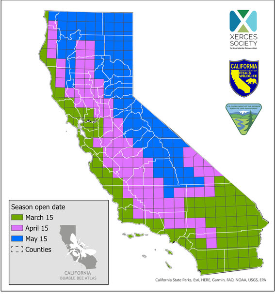
We want you to survey when you have the best chance of finding the full diversity of bumble bee species that occur in your chosen survey location. At the same time, we want you to time your surveys so that you are less likely to encounter queen bumble bees, who may be more sensitive to handling that workers and males, particularly in spring when they are founding colonies. California is a large and varied state, so bumble bees become active at different times in different places. In light of this, we have divided the grid cell map into three groups with different "open season" or official project launch dates, as depicted in the map below. We think that much of southern California and the coast should begin surveying on March 15. We open the Central Valley and lower elevation areas of eastern, central, and northern California on April 15. And, we open montane and more northern parts of the state on May 15. We realize that the diversity of climates and habitats in the state means that these dates will not be quite right for some areas, but think this map strikes a good balance between project needs and safety of queens in spring.
Step 1: Make Your Choice
In our first field season, we identified around 200 "priority" grid cells (from a total of 275) to guide volunteers in their selection of field sites. In 2024, we are considering the entire state of California a priority (and thus, all grid cells in the map)! Use the interactive map below to explore project grid cells and find where you'd like to do surveys. Zoom in to reveal the grid cell number labels. We have retained the same numbering system we used last year, but have back-filled the map with new grid cell numbers as necessary, so be aware that some numbers are not in sequence. The button in the upper left hand corner of the map allows you to see the legend. The stacked icon in the bottom right corner allows you to view three separate layers of information, and you can turn these on and off by clicking the eye icon. The default layer is the grid cell map. The other two layers are 1) a map showing which grid cells we surveyed last year; and 2) a map showing which grid cells include lands managed by the Bureau of Land Management (BLM). We'd prefer if you choose a grid cell that was not surveyed last year, so consult that layer to find these cells (that said, it's okay if you want to survey a previously surveyed cell). And, within your grid cell, we are hoping that you will consider conducting your surveys on BLM lands, given that BLM is a major funder of our 2023 field season. It is ultimately up to you which grid cell you choose and where within that cell you decide to survey, but please consider using these tools as you make your selection.
We will soon be sharing a map to show you exactly where those BLM properties are found.
Record the grid cell number of the cell you'd like to adopt and enter it in the form below the map (Step 2). You can also change the basemap (to aerial photography, etc.) by clicking on the four square icon in the upper right.
If you prefer, you can explore the grid cells at this Google Map application. You can download the grid cells as a .kml layer from this site, and .kml files can be imported to other mapping platforms, including Google Earth. (To do this, in the Legend/Table of Contents, click the three dots to the right of the layer name, then select 'Export data'.) Either way, use the form below at Step 2 to record your grid cell choice!
Please note that grids can include both public and private land, and Xerces volunteers may not trespass on private land. When at the site, please carefully look for markers of private land, such as fences or hedges that define property boundaries, gates whether locker or unlocked, and posted signs prohibiting trespass; respect the landowner’s property rights and do not trespass. If you find yourself on private property without permission or you have been asked to leave, please leave immediately even if your survey activity is incomplete. If you are uncertain as to whether property is public or private, assume it is private, stay on the public roads adjoining the property when performing the activity, and do not enter the property itself without obtaining permission from the owner. For your own protection from trespass claims, the permission should be written.
Step 2: Adopt your grid cell by filling out the form below.If you are on a mobile device or otherwise having difficulty, you can find the entire form here.
You can download the volunteer liability release form here.
|
Step 3: Encourage others to adopt their grid cell today!
Click to download and share! (Image opens in a new window; right click to save to your computer)
Thank you!If you have questions, please feel free to contact us.
|
COVID-19 UPDATE: We understand that the current situation with the coronavirus is constantly evolving and differs by community. The most important consideration during this sensitive time is personal and community health. Please follow all relevant regulations and the advice of health care professionals when developing your survey plans for the Atlas. Don't hesitate to stay closer to home if that is the right thing for you and/or your community; the health of our volunteers is of paramount importance. Thank you!